|
||||||
|
Reading the Sundial
|
||||||
|
There is lot of information in one of these sundials. Here's what you need to know
to unpack it
|
||||||
|
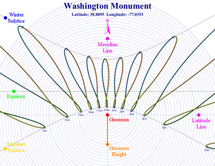
Gnomon is the "pole" used to cast the timekeeping shadow. It can be anything, from a short post on a home sundial to an obelisk like those constructed around the world since antiquity - or the Washington Monument. Since we're looking down on it, all we ever see of it on the sundial is its cross-section. |
||||||
|
Gnomon Height is represented by the length of the orange line. If you were using this image for a working sundial, it would be exactly that length. Or, in this case, it's the height of the Washington Monumment. |
||||||
|
Latitude Line represents the exact line of latitude where the gnomon is located. Meridian Line represents the nearest time zone meridian to the east. It is always aligned to true (not magnetic) North. In the basic scheme behind global time zones, the Earth is divided into 24 wedges of 15° each, starting with the "Prime Meridian" at Greenwich, England. The time in each zone is determined by the time on its eastern boundary, so the Meridian Line in these sundials is always associated with that boundary. |
||||||
|
Winter Solstice represents the line traced by the tip of the gnomon's shadow on the day of the Winter solstice. The shadow never goes beyond this line. |
||||||
|
Summer Solstice represents the line traced by the tip of the gnomon's shadow on the day of the Summer solstice This is always the line closest to the base of the gnomon if you define "Summer" as the equinox when the Sun is highest in the sky. It has no real meaning at the Equator, where the solstices are interchangeable. The shadow never goes beyond this line. |
||||||
|
Equinox represents the line traced by the tip of the gnomon's shadow on the Spring and Autumn equinoxes. And yes, it is a straight line. |
||||||
|
The analemmas on the sundial represent every point the shadow's tip touches at that *clock* time each day throughout the year. It's important to remember that an analemma is only a collection of points marked daily over the course of a year; nothing ever actually traces out that shape. They are color coded here to indicate the season: yellow for Summer, orange for Autumn, blue for Winter, and green for Spring. The times shown are Standard time for that geographic time zone, and take into account neither political or other deviations in the boundaries, nor Daylight time. |
||||||
|
If you look at the "Noon" analemma, you can see it is offset to the left. The time zone is set by the meridian at -75°, and the Washington Monument is at -77.0353°, or 2.0353° to the west. Therefore at Noon, clock time, the analemma reflects that the Sun is still east of directly overhead, and so solar noon comes a few minutes later. |
||||||
|
This sundial is essentially a map of where the Sun is in the sky for every hour of every day of the year. The bullseye grid can be used to measure the length of the gnomon shadow at any point, and since it's based on the height of the gnomon as '1', it reads out the cotangent of the angle of the Sun above the horizon directly. For instance, at 10 AM on the Winter solstice, the shadow is 2.65 gnomons in length. So the Sun is (arccot 2.65) 20.7° above the horizon, called its "altitude". Further, the angle of the Sun can be read from the sundial with a protractor centered on the gnomon. Which in this case is about 56°. Since the shadow is in the northwest quandrant, the Sun is about 56° south of east in the sky, corrresponding to an "azimuth" of 146° (90° + 56°). |
||||||